Verdun is in the east of France, not far from the borders with Belgium, Luxemburg and Germany. Driving to Verdun from the channel ports takes about 4-5 hours. Depending on where you live in the UK, it can make sense to get the ferry to one of the Normandy ports (Le Havre or Caen). The drive in France is a little longer, but generally French motorways are less busy and you can make quicker time than in the UK.


In both cases, you can make the vast majority of the trip on motorways, although you will pay about €30-35 in tolls. The A4 Motorway runs to the south of Verdun, and you can exit to the west and then drive on the Voie Sacrée towards the town itself.
Verdun itself has several hotels to choose from, plus other types of accommodation. For example, in the centre of the town is the upmarket Les Jardins du Mess, which also has a good restaurant, and there are places to eat out in the town centre. However, parking in the centre of Verdun can be a problem when staying in the town centre. Some central hotels offer parking, free or paid.
On the south-east outskirts, about a mile and a half from the town centre, are the medium priced ibis hotel and the low-cost Formule One, for the latter rooms are not en-suite. Choice of restaurants and where to eat are more limited here however, unless you wish to drive.
Verdun Books and Guides
There are fewer books (in English) dealing with Verdun than the Somme or Flanders – as you might expect. Two good accounts of the battles are Alistair Horne’s The Price of Glory and Ian Ousby’s The Road to Verdun.
In terms of guidebooks, the Holts cover Verdun in their Battlefield Guide to the Western Front South. This, as is the norm with their guides, is in the form of a car trip around the battlefields, visiting many sites of interest. If you only have one day then this would be a good option.
A recent publication (2019) by Christina Holstein is an excellent addition for a longer visit to the Verdun area. This is Walking in the Footsteps of the Fallen, and it contains a number of walking routes to visit areas within the forests around Verdun, where the remains of trenches, pillboxes, and the scars of the fighting are still visible. Another book, Fort Douaumont again by Christina Holstein and published by Pen & Sword covers Douaumont in detail, but also has a suggested itinerary for the northern part of the battlefield, including the fascinating Camp Marguerre.


In terms of maps there is an excellent 1:25,000 special map published by IGN which covers the major part of the Verdun battlefields. This is sheet 3112ET , Forets de Verdun et du Mort-Homme. The area is also covered by the ordinary IGN Serie Bleue maps 3212O, which covers an area slightly further east than the special map. The special map is worth purchasing, as it is marked with areas and sites of interest to the battlefield visitor. It is worth noting that the area to the north of Douaumont is closed to the public on Mondays and Tuesdays, as it is a military firing range. However, it is still possible on those days to access Douaumont village, which is very near to the restricted area.
The area is great to walk around, and there are a series of marked walks in the forested area of the battlefields which can be easily followed. They are marked on the special IGN map listed above. There are also route plans for the walks available at the Memorial, and these show points of interest on the way round. It can be very muddy, so good walking boots are essential. It is also a popular area for mountain biking, if you are fit enough (some areas are very steep).
Summary of the Main Verdun Area Sights
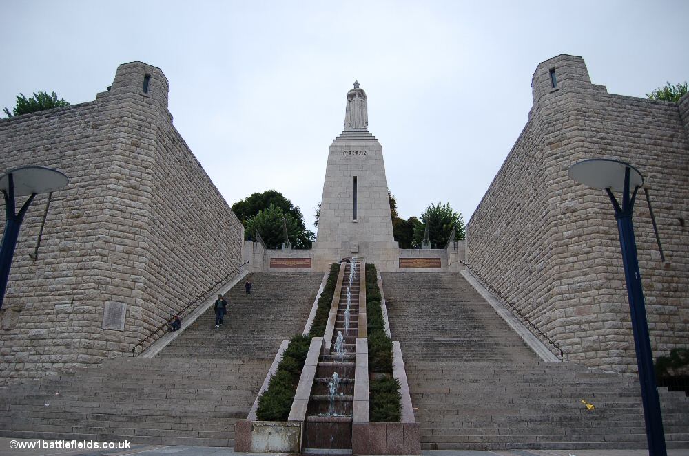
There is so much to see in the area that the details are covered on several pages which remain in the original World War One Battlefields website format. Links to these are given in each section below, where a summary of some of the most important sites are listed. In Verdun itself is the imposing Victory Monument, set into the town walls. Small fountains play in the street leading up to it, and in the middle of the steps which lead up to it.
The monument was inaugurated on the 23rd of June 1929. At the top of the steps is a 90 foot tall column on which stands the figure of a knight, and a pair of Russian field guns flank the column. There are annual commemorations here in June each year.
-

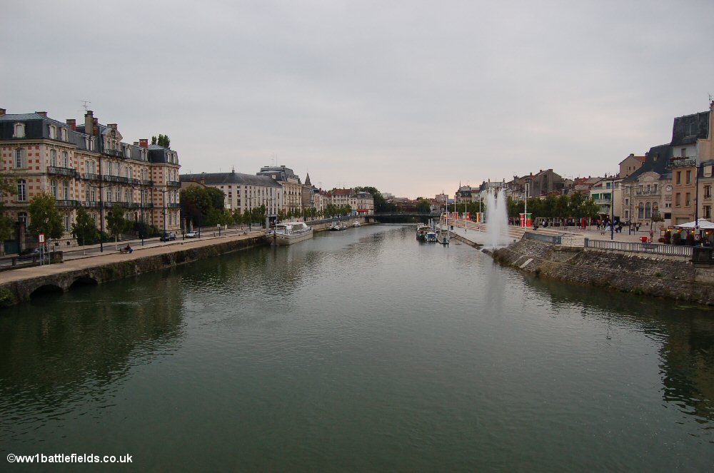
- The River Meuse running through Verdun
-

- The imposing Victory Monument
-

- One of the field guns at the Victory Monument

More information can be found on the Verdun town page.
The Central Area – the Ossuary and Trench of Bayonets
Right at the heart of the Verdun battlefield is the massive Ossuary. This was inaugurated in 1932, and inside the base of the building are collected the bones recovered from this battlefield – an estimated 130,000 skeletons. Walking around the building one can peer through the small windows to see these grisly reminders of the bloodshed here. Through some of the windows can be seen neatly piled long-bones; through others jumbles and scraps of bones as well as skulls.


Inside the Ossuary itself, the atmosphere is hushed, and the smallest sounds echo along the halls. There are two main arms of the building leading off left and right from the entrance, with candles at each end. Their flickering flames glow amidst the dim orange light that permeates the interior. Along the hall are alcoves (with the names of areas of the battlefields inscribed above them), and mock tombs inscribed with the names of cities in France. Names are also inscribed on panels on the walls and the roof.
On the slope below the Ossuary are the crosses of the French Cemetery here – a further 15,000 French soldiers are buried here, in the regular rows of graves seen in French military cemeteries. The ground is undisturbed near here, showing the scars of the battles.
Located a little way along a small road leading north from the Ossuary (the D913) is the famous Trench of Bayonets. A long low concrete structure has been built to cover the site.
An ornate green bronze gate, decorated with a sword entwined by vine leaves leads into the site. The crosses of the Unknown French soldiers lined up within the covered area are perhaps one of the iconic sights of Verdun.


More information on these and other sites can be found on the Central area page.
Fort Douaumont
This is one of the main sites in the Verdun battlefield. Fort Douaumont was one of a series of forts near Verdun, constructed after the Franco-Prussian War to defend against future attack. However, when the German offensive near Verdun began in early 1916, only a tiny garrison of 57 French soldiers remained. The Germans captured Fort Douaumont on the 25th of February 1916 with relative ease.


Several kilometres of tunnels run inside the Fort and some areas are open to the public. Dormitories, officers quarters, barracks and kitchens, plus latrines can all be visited.
There is also the ‘German Cemetery’, where somewhere between 800 and 900 Germans were killed in an explosion which occurred at 6 a.m. on May the 8th, 1916. It happened when a store of grenades exploded, and nearby flamethrowers also then ignited. The appalling scenes can only be imagined. Some of those who died were buried outside the Fort, but there were so many bodies that many were walled up in two casemates here in the Fort itself. Six hundred and seventy-nine lie behind the wall here marked with a cross remembering “the Dead Comrades”. There is also a metal plaque on the wall to the left commemorating those who died here.


As for the exterior, it is possible to walk up onto the top of the Fort, using paths that lead up from the sides of the main structure at the front. On the way around, one can see the fortifications and defensive positions that were built into Fort Douaumont. On the top of the Fort, there are a number of machine gun turrets and observation positions visible. The largest concrete base is where the 155 mm machine-gun turret seen on the interior of the Fort is positioned.


More information can be found on the Fort Douaumont page.
Destroyed Villages – Fleury & Douaumont
There are several villages in the area which were totally destroyed in the Great War. The site of Fleury village is well signposted. There are information boards giving facts and figures. In 1913 there were 422 inhabitants of the village, among them several farmers, a tobacconist and a baker. The village had only three streets, and in 1972 their routes were retraced, marked by white posts. A stone marker was placed on the site of each house, shop and also the school, church and Mairie.


Shelling started on the morning of February the 21st 1916 and the villagers left in great haste, leaving food half eaten and boarding carts and leading their livestock to Bras-sur-Meuse. By May, all that remained were ruins and from June until August the village changed hands some 16 times, as this was a key location in the defence of Verdun. This was total war, and resulted in total destruction of this once peaceful rural settlement. There is a Memorial Museum at Fleury, opened in 1967, on the site of what had been Fleury station.
Another of the destroyed villages was Douaumont. The ground here bears the scars of the furious shelling that took place. Before the war, the village had a population of nearly three hundred, including a cobbler, a tobacconist, three stonemasons, several farmers and a teacher.
There were around fifty houses, and their sites have been marked by wooden stakes.There are larger markers showing the location of the Marie and School, and a stone marks the fountain. This and a few lumps of stone are all that remain to show that a village once stood here.


After the War ended, the villagers returned to the area, but the danger from the munitions that had poured into the village was deemed too great to allow it to be rebuilt. In 1926, a war memorial was erected to commemorate the eleven men from Douaumont who were killed in the Great War.
More information can be found on the Fleury and Douaumont village pages.
Fort Vaux
Like Fort Douaumont, Fort Vaux was another of the series of forts near Verdun, constructed after the Franco-Prussian War to defend against any future attack. One can walk around the top of the fort and as at Fort Douaumont there are excellent views over the surrounding countryside.


The Left Bank of the Meuse
Mort-Homme was a small hamlet before the war. There are the remains of trench lines in the trees nearby, but without doubt the most striking and well-known feature here is the main Mort-Homme monument. The famous Mort-Homme ‘Skeleton Memorial’ commemorates those of the 36th Division who fought and died here. It is estimated that 10,000 Frenchmen lost their lives here.


The memorial was unveiled in 1922. On the front is the famous phrase “ils n’ont pas passe” (“they did not pass”), which came to represent the need and desire of the French to hold onto Verdun. On the plinth of the memorial, officers are listed by name, but there are simply lists of regiments to remember the rank and file soldiers who died.
There are other interesting sites in this area, and more information can be found on the Left Bank page.
The Northern Area & Camp Marguerre
There are two German cemeteries in the northern area. Near the village of Azannes is Azannes II German Cemetery. In Mangiennes is another German cemetery, which is extremely interesting because of the original grave markers that can still be seen.


Near the village of Pillon is the site of the ‘Long Max Cannon‘ (signed as Site du Canon Allemand). The massive gun located here fired the opening shot in the Battle of Verdun. This was originally a naval gun, intended for a battleship which was never completed. The breech of the gun alone weighed over two tons. Each shell weighed 750 kg, and they were transported by small carriages on tracks. When the gun was fired, a fifteen metre long flame came from the muzzle, and the noise could be heard from miles around.


In the area around Verdun there are many bunkers and a couple of examples are shown below.


There are other interesting sites in this area, and more information can be found on the Northern Area page.
Camp Marguerre is located some ten miles or so north-east of Verdun. This was a German experimental site where the use of concrete was studied. It is set deep in a forested area (Spincourt Forest). Captain Marguerre, after whom the Camp is named, was an engineer who worked in Berlin before the War. He and his men were sent to the Spincourt sector, to create a camp to test the use of concrete in war fortifications. This is a small village made up of concrete buildings – not all of which are conventional bunkers or blockhouses.


Inside the commandant’s house and living quarters the traces of wall decorations can still be seen, with decorative borders towards the tops of some walls. Every attempt was obviously made to make this place as comfortable as possible. And being behind the lines and well camouflaged, life was probably relatively peaceful and regular, compared to those involved in the fighting nearer to Verdun.
In 1918 the Germans abandoned the site, and in 1919 the local inhabitants removed much of the furniture and fittings that they left behind. During the Second World War, the French Resistance used the buildings here as hideouts to avoid discovery.
More information can be found on the Camp Marguerre page.
You must be logged in to post a comment.